December 4 & 5, 2015 Published December 13, 2015
After settling in to the
campsite at Jeff Busby Camp area, early afternoon for a change, I hiked up to
the top of the highest point in Mississippi – a whopping 603 feet above sea
level. Since I started way down below it was another one of the heart stress
test climbs. Paved all the way but steep nonetheless.
Next morning, I was off to
the road, bright and early. I figured I’d get some sightseeing in and then stop
for breakfast along the way.
French camp is the site of
Louis LeFleur’s stand (inn) which he opened in 1812. Today it is the site of a
private interdenominational school which operates the historical village that
is open to the public. The school was founded in 1885 by the Presbyterian
church as a boys school, integrated with a similar girls school in 1915 and
continues on today with the same high standards.
 |
| Rear Staircase in center of house |
 |
| Drane Home |
 | |
| Blacksmith Shop |
Unfortunately I was there
before the gift shop and the café opened for the day but I spent a good while
wandering the grounds.
A quick stop at the Kosciusko
Welcome Centre to grab a geocache turned in to an hour long visit with the
woman there who was a fellow geocacher. I just might have turned her loose on
travelling the nation as well. Finally bidding her goodbye and urging her to
get out and enjoy herself, I headed south in to Choctaw territory.
A stop of at the Upper
Choctaw boundary was neat – the trees are still standing somehow or as I
suspect, they’re new trees that have been allowed to stand in place of the
original ones.
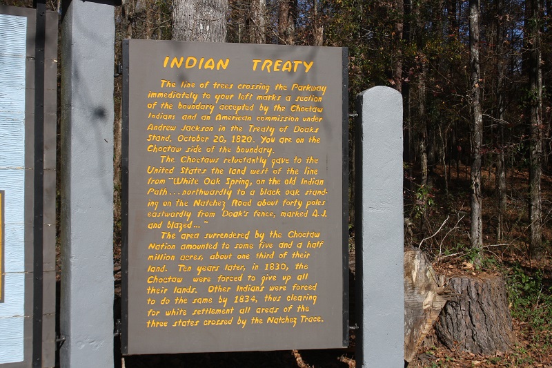 |
| Upper Choctaw Boundary |

 And then the Cypress Swamp. I
met a lady sitting on a big log with a camera lens to envy. I’m sure with my
hiking poles and my clomping down the trail, every bird within a ¼ mile had
taken flight but we had a good chat and I left her to wait for the birds to
return. Interesting cypress trees, I don’t think I’ve seen them that large
before.
And then the Cypress Swamp. I
met a lady sitting on a big log with a camera lens to envy. I’m sure with my
hiking poles and my clomping down the trail, every bird within a ¼ mile had
taken flight but we had a good chat and I left her to wait for the birds to
return. Interesting cypress trees, I don’t think I’ve seen them that large
before.
A quick stop at what used to
be the Florida boundary, another burial mound site, a couple of smaller battle
sites and I arrived at the Lower Choctaw Boundary.
 |
| West Florida Boundary |


And I was in to the last
camping area on the Trace Parkway with plenty of time to sit and enjoy some
late afternoon sunshine. Obviously, I’m moving right along now – a grand total
of 138 miles of the parkway done today.
No comments:
Post a Comment